Mon - Fri: 8 am - 4 pm MT

About Backcountry Journeys
Why Choose Backcountry Journeys
If you're considering a photography trip, hear why Backcountry Journeys delivers the best experience in the industry.Frequently Asked Questions
If you're new to photography trips, or new to BCJ, you can find our common travel questions here.Fitness Levels
Our trips vary on physical intensity, and by reviewing our fitness levels, you can find out which trips may be more challenging, or aligned more closely with your comfort level.Meet The Crew
We've built an amazing team of experienced guides, and dedicated office staff that elevate your travel experience. Get to know their backgrounds, and hear their stories.Loyalty Program
We reward our frequent photo adventurers with exclusive discounts on amazing photography trips.Contact Us
If you need to get in touch with our office staff, or have additional business inquiries, you can find our information here.Refer a Friend
Know someone perfect for one of our tours? Recommend them through this quick form.Stay Up To Date On All Things
Backcountry Journeys
Backcountry Journeys
Our Photography Community
Our Webinars
Our regularly hosted webinars provide photography instruction from our own guides on a wide range of topics.Our Education Portal
Explore our library of articles that cover everything from common questions, to in-depth guides on how to achieve that perfect shot.Community Testimonials
We're proud to foster an amazing group of photo travelers, and here you can find their stories from their past adventures.Resources For Photographers
About Our Company
Resources For Photographers
About Our Company
Trip Report: Death Valley: Land of Extremes II – February 2022
Published May 9, 2022
Pete Aguereberry arrived at what is now Death Valley National Park in 1905 on a quest for gold. After escaping his own death in June of that year, he settled into what became a lifelong love affair with mining and living in the high country of the Panamints, a mountain range that borders and towers high above the dry, salty, and miserably hot valley below. While Aguereberry, like many other miners at the time, found success, his greatest discovery might have been what historians have called Death Valley’s ‘most precious resource’ … Solitude.
Today, visitors and photographers, like us, find Death Valley to offer up riches of a different kind than that of ore. Riches from the diversity of the area’s perplexing landscapes. Death Valley is the largest National Park outside of Alaska, and because of that, finding solitude is possible, especially if you know where to look.
Opportunity abounds in this place called “Death,” and, an inclined nature photographer with a mindset similar to Mr. Aguereberry could certainly spend a lifetime here looking to record in pictures their own version of found solitude and contentment. It’s all here – in the salt, or mud-covered playas, in highpoint perches offering “The Great View,” in the colorful and otherworldly badlands, or out there amongst swirling dunes of sand as they constantly reshape and replenish.
Guests on February’s Death Valley: Land of Extremes tour had only roughly a week to discover exactly what this place might mean to us, but divine time swiftly took the lead as the wilds and unexpected of this corner of eastern California provided many a moment, and composition, to help us to tell our own story of one of the more unique landscapes anywhere.
To do a good job photographing Death Valley, one must be open to being creative, and patient. Photographers looking to advance their skills, especially with techniques like focus stacking and image blending, have a lot of opportunities to do so. The former is a skill utilized in order to obtain sharpness throughout an image with a prominent foreground. The latter blending multiple images with different exposure levels in order to achieve one final image with perfect lighting. Photographing large, swirling sand dunes is a test to the creative mind, as well. What one can do during an evening at the dunes is really only limited by imagination, and can be exceptionally fun if you’re willing to live and shoot in what some may consider less-than-desirable conditions (like blowing sand all over the place).
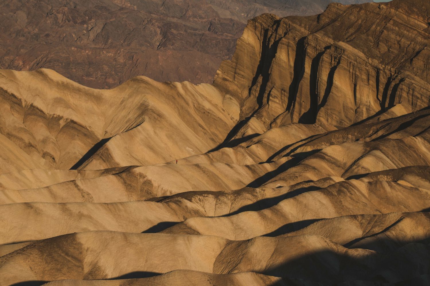
We arrived at the park following a 2+ hour drive from Las Vegas, stopping first to check out Zabriske Point, one of the more popular locations in the park. With no clouds in the sky, the mid-morning sun created harsh conditions for traditional landscape photography, so we talked about different things that one can still do, even with less-than light. Thinking in terms of black-and-white and abstract opportunities was discussed and practiced. We’d shoot sunrise at this spot later in the trip, so no pressure here, but what we were able to practice, and think about during this stop would help us down the road as we opened our minds to what is possible here. Death Valley is not as “cut-and-dry” as other spots like say, Glacier National Park, where the obvious image is, well, obvious. More on this later.
Dining at Death Valley can be hit-or-miss, and the more you know the better off you’ll be. We ate as often as possible at the luxurious, and historic, Inn at Death Valley while mixing in fun stops at local dives with names like ‘Badwater,’ ‘Last Kind Words Saloon,’ as well as at a roadside watering hole located quite specifically right in the middle of “noplace,” Panamint Springs. When we made time for a few hours of sleep each night, we did so at Furnace Creek, a fantastic little oasis of emerald amongst a vast expanse of brown baked desert. Because of the tree cover, some exposed water, and greenery at Furnace, it just might be your best Death Valley opportunity to photograph wildlife, be it a coyote, roadrunner, or a Say’s Phoebe. It was here at Furnace Creek that on the afternoon of July 10, 1913, the United States Weather Bureau recorded a high temperature of 134 °F, which stands as the highest ambient air temperature ever recorded on the surface of the Earth
The flow for the early portion of this trip was as such: drive up to a spot that seems not unlike any other along a dusty long stretch of road, get out, grab our things (all of your things – yes, your tripod, too), and then walk for what feels like forever (“.5 mile,” maybe, says the guide) out to a spot in the middle of a mud/salt playa. We find ourselves surrounded on nearly every side by mountains, the Panamints to our west, the Amargosa Range to the east. The valley, where these playas exist, stretches north to south for hundreds of miles.
“So, what are we looking for,” one might ask. Well, look down. See those large, crazy interesting, and almost curiously congruent mud cracks? That’s what we’re looking for!
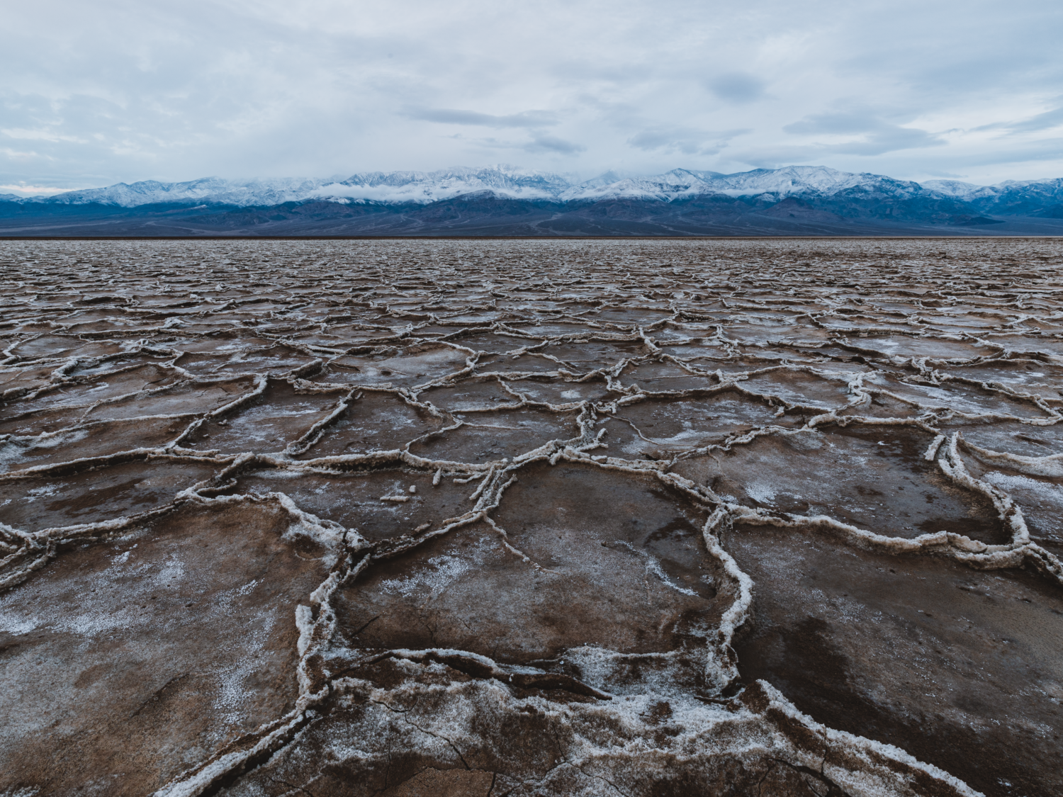
Combined these foreground cracks (or salt formations depending upon where you are at the time) with the soft light of sunrise or sunset and the mountain backdrop, you have a new brand of Death Valley ‘gold!’ It just so happened that we had snowy mountain peaks and, on occasion, puffy storm clouds hovering on the peaks to go with. Snow in an image of Death Valley? **insert chef’s kiss here.**
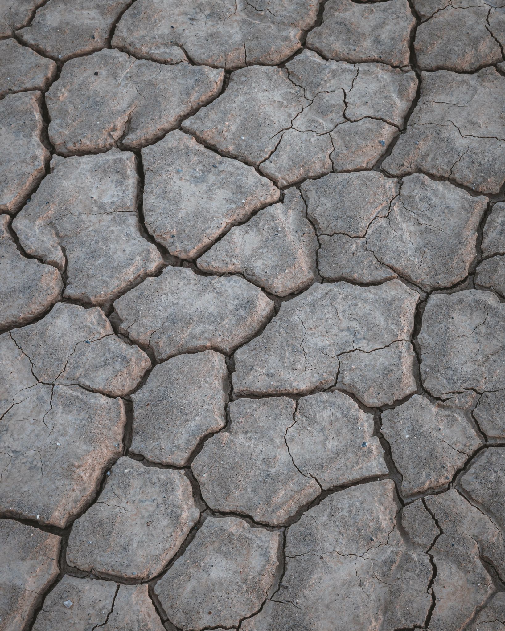
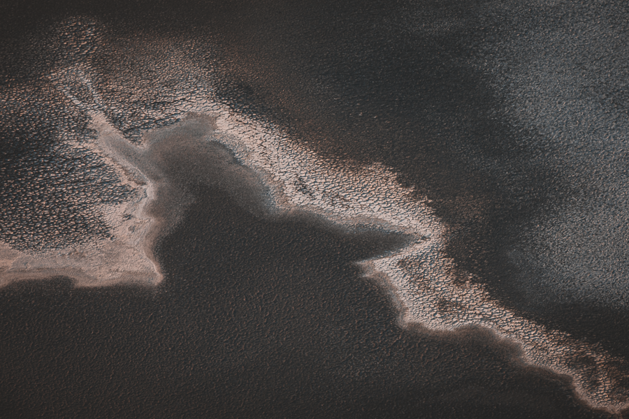
Whether our daily quests led us to remote playas mud crack playas, or locations such as Badwater or Cottonball Basin, where interesting formations of salt exist, our thought process remained consistent: achieve a nice composition utilizing these otherworldly foregrounds. Shapes, lines, textures. Then, maybe turn those thoughts loose on abstracts.
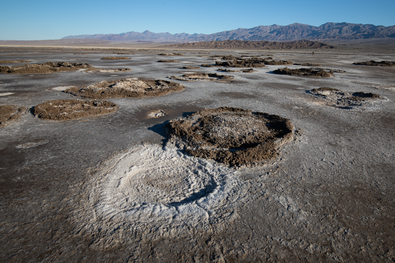
What can be done with an image featuring perhaps nothing but these iconic geometric salt polygons that form here as groundwater rises up through these deposits and evaporates?
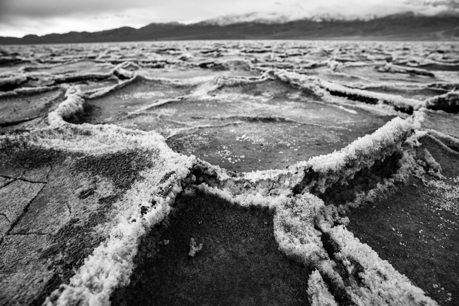
Badwater Basin is one of the park’s most popular spots, and is home to the lowest elevation in North America, at -282 feet below sea level. It gets its name from an old tale of a mule belonging to an early surveyor refusing to drink from the spring-fed pool. The water wasn’t “bad” per se, it was just salty. Saltier than that of ocean water, actually.
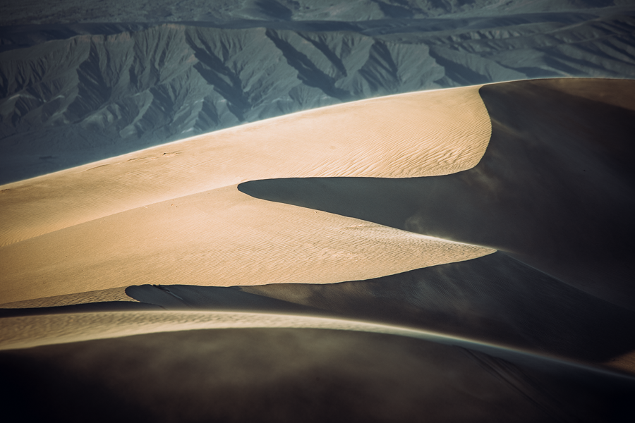
Photographing the Mesquite Flat Sand dunes is an experience unlike most. But, what are these dunes? Why are they in one spot, but not another? There are, in fact, only a few locations where sand builds into large dune fields, like the one at Mesquite. There is a recipe to the development and continuation of these dunes: there must first be a source of sand. Here that source is the mountains to the north. Second, there needs to be a significant wind to move that sand, and third, a barrier to prevent the sand from being blown farther (the mountains to the south).
Shooting here can’t be done with any real intention of quality from the side of the road, or near the parking lot where 95% of visitation takes place. To truly tackle the dunes and get the shot, you have to get in there and be ok with a little bit of misery. The dunes are a solid spot to shoot in nearly any conditions, however, they’ve become known for dramatic shadows at sunrise and sunset, as ripples and edges in the dunes stand out in greater contrast. And if you are able to score that nice lowlight combined with enough wind to visibly blow the sand across the lines and tips of the dunes, you have a landscaper’s cash cow! With any luck, say a stray shower, or even virga, featuring colorful clouds filling the sky, you’ll have a fantastic wider shot featuring the dunes and the sky. If there are no clouds, have no fear, look for compositions utilizing the contrast between the golden glowing sand on one side of the dune with dark shadows on the other.
Shooting here can’t be done with any real intention of quality from the side of the road, or near the parking lot where 95% of visitation takes place. To truly tackle the dunes and get the shot, you have to get in there and be ok with a little bit of misery. The dunes are a solid spot to shoot in nearly any conditions, however, they’ve become known for dramatic shadows at sunrise and sunset, as ripples and edges in the dunes stand out in greater contrast. And if you are able to score that nice lowlight combined with enough wind to visibly blow the sand across the lines and tips of the dunes, you have a landscaper’s cash cow! With any luck, say a stray shower, or even virga, featuring colorful clouds filling the sky, you’ll have a fantastic wider shot featuring the dunes and the sky. If there are no clouds, have no fear, look for compositions utilizing the contrast between the golden glowing sand on one side of the dune with dark shadows on the other.
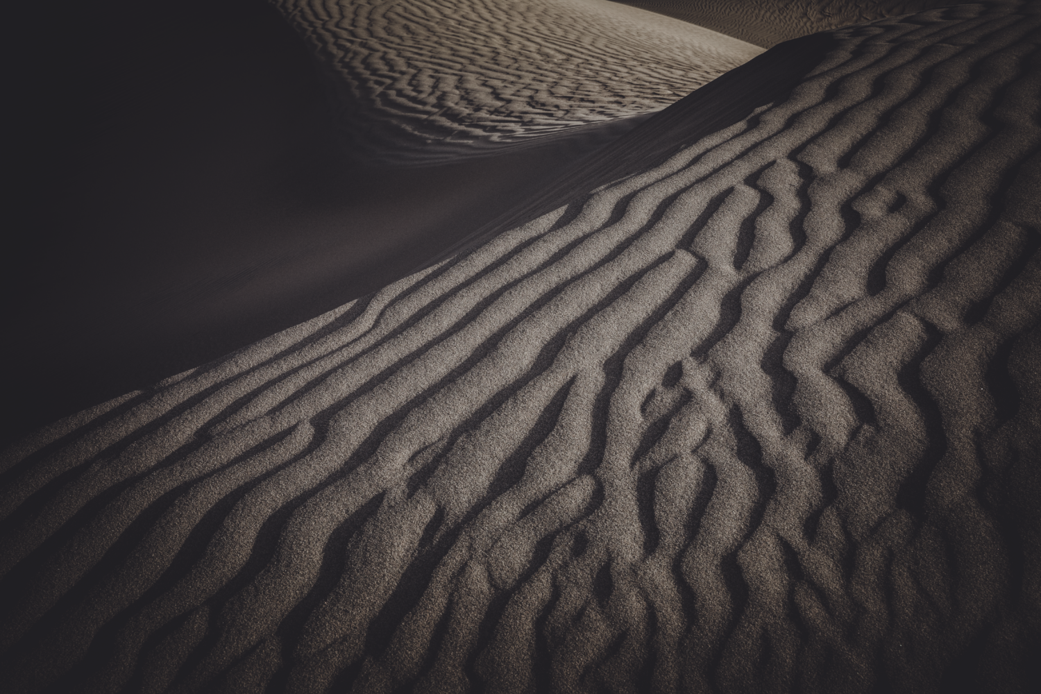
Don’t be shy, and fight the urge to get stuck on just one thing. Look for abstracts and interesting and peaceful scenes amongst the chaos of moving sand (and footprints). We did just this on our evening in the Mesquite Dunes. There was just enough wind to move the sand the way we were hoping, and we did have interesting light and clouds in the sky. Certainly, a fun evening shooting in an environment many on the trip had not previously attempted. Just be careful, it’s not advised to change lenses standing on a sand dune during a sandstorm.
Standing in the middle of a playa or salt flat looking down/up is one way to see Death Valley, but it is not the only way. How about from above looking down and across? For our final day + together we’d explore more traditional landscape opportunities. The aforementioned Aguereberry Point offered a fantastic composition looking down across a portion of the valley below. But, more than just a photograph, the morning offered a moment of true peace for those who were interested in finding some. The quiet stillness was in abundance from 6,433 feet. Snow had fallen at this elevation earlier in the week and remained for our chilly morning session at what miner Pete Aguereberry called “The Great View.”
Standing in the middle of a playa or salt flat looking down/up is one way to see Death Valley, but it is not the only way. How about from above looking down and across? For our final day + together we’d explore more traditional landscape opportunities. The aforementioned Aguereberry Point offered a fantastic composition looking down across a portion of the valley below. But, more than just a photograph, the morning offered a moment of true peace for those who were interested in finding some. The quiet stillness was in abundance from 6,433 feet. Snow had fallen at this elevation earlier in the week and remained for our chilly morning session at what miner Pete Aguereberry called “The Great View.”
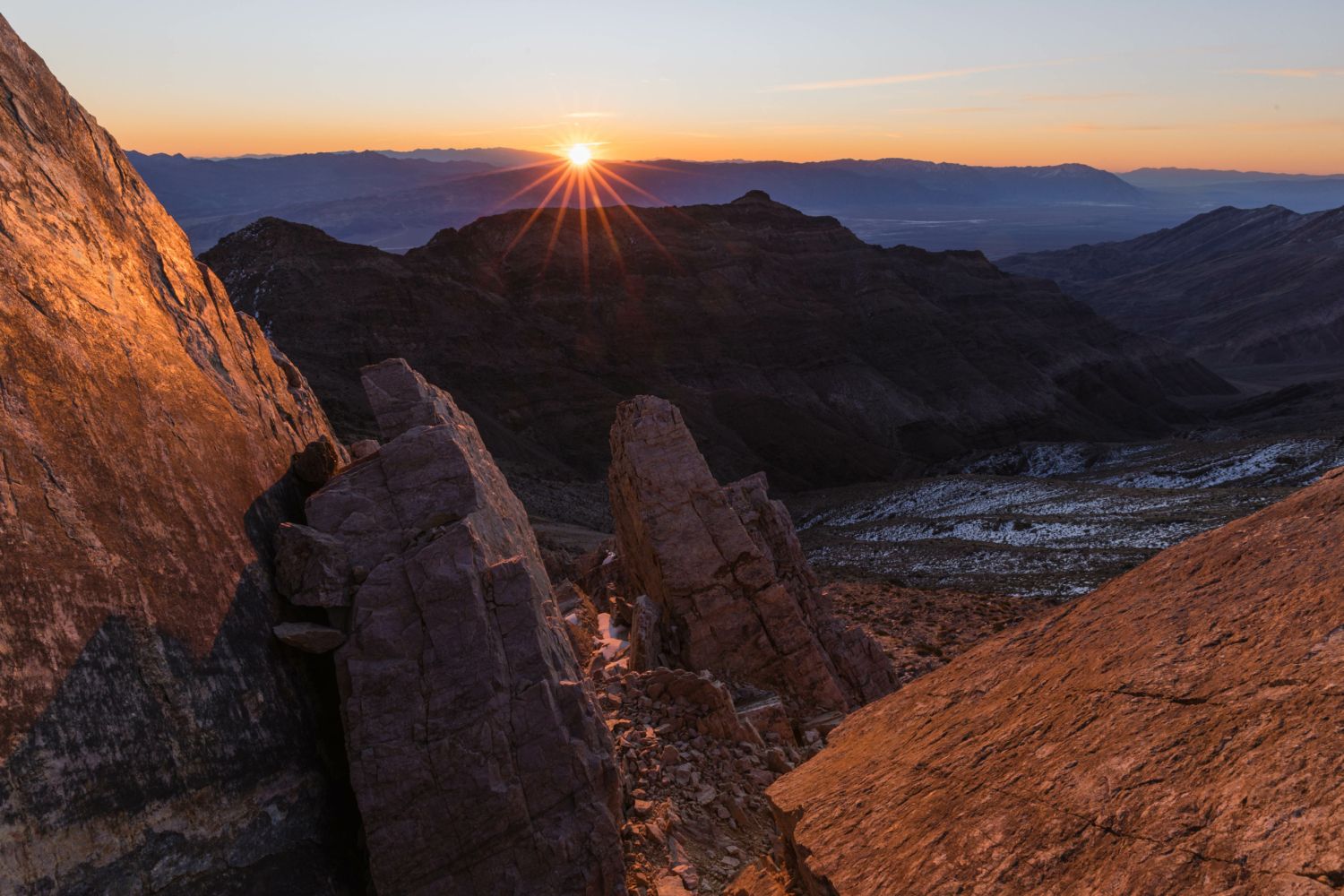
Our group would wholeheartedly agree with Aguereberry. Utilizing a rock outcropping featuring jagged boulders perfectly placed, as if on purpose, our compositions were framed nicely and included leading lines from the mountain landscape as they stretched down and in towards the valley. The sun rising on a cloudless eastern horizon provided for a sun star peaking over the valley with a reddish-orange glow on our foreground rocks. One thing landscapers should always remind themselves to do while shooting sunrise (or sunset, or whenever) is to turn around. Those who did from this spot were able to see the snow-capped jagged peaks of the far-off Sierra Nevada range on the western horizon.
Another high point (pun intended) was on tap for our final evening together, this time across the valley at Dante’s View. Towering 5,575 ft directly above Badwater Basin, on the ridge of the Black Mountains, Dante’s View is a favorite spot for photographers as it has an unparalleled view of a huge portion of Death Valley below.
Another high point (pun intended) was on tap for our final evening together, this time across the valley at Dante’s View. Towering 5,575 ft directly above Badwater Basin, on the ridge of the Black Mountains, Dante’s View is a favorite spot for photographers as it has an unparalleled view of a huge portion of Death Valley below.
Long lenses can be utilized here, too, for the creative looking to isolate the interesting lines, shapes, and movement of the playa below.
“I don’t pay much attention to scenery, but I know one view that made me stop and look.”
– Charles Brown, a local man from Shoshone, when asked in 1926 by the governor of Nevada for his opinion of the best view of Death Valley.
“I don’t pay much attention to scenery, but I know one view that made me stop and look.”
– Charles Brown, a local man from Shoshone, when asked in 1926 by the governor of Nevada for his opinion of the best view of Death Valley.
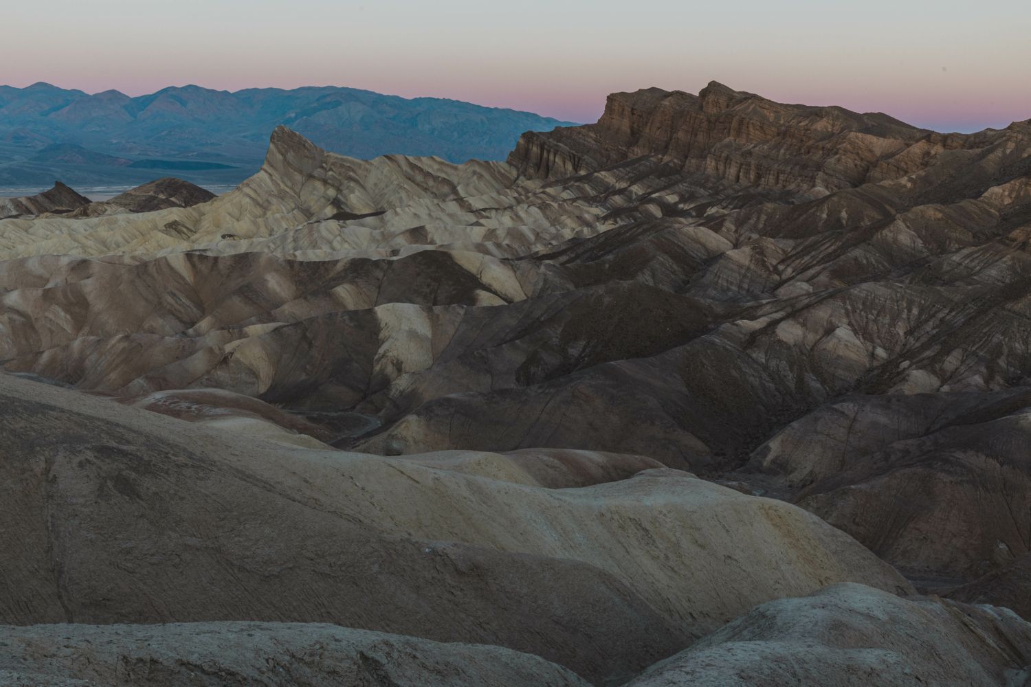
Our final morning together was spent back at Zabriskie Point, just in time for sunrise and the soft glow of early morning, and it did not disappoint. The light from another cloudless sky peered over the ridge and cast across the otherworldly and colorfully striped badlands here offering nice compositions of the sprawling landscape leading to the famous Manly Beacon, a particularly striking wedge of rock in the midst of it all, yet prominent.
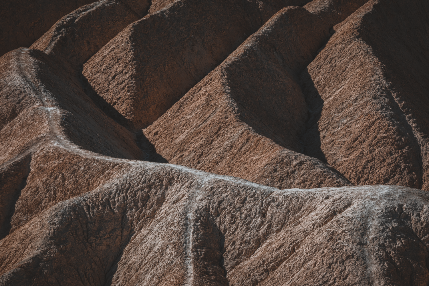
This area is special for its unique geology. These yellow and brown striped hills, or badlands, are the result of layers and layers of sediment that filled freshwater lakes here before drying out and then eroding to put on display fabulous and colorful mounds of soft sedimentary rock. The area has been shaped by the powerful force of water and time. Other spots in this Badland area of the Black Mountains that were paid visits to include Artist Palette and 20 Mule Team Canyon, named after the famous mule teams that delivered borax from the mines at Death Valley to the railroad lines 160+ miles away. Artist Palette is tucked behind an unassuming yellow landscape, but for those willing to adventure up the road, the reward is a rainbow-colored mountainside displaying an array of colors (red, orange, yellow, blue, pink, and green), splashed across the hills. These colors are from volcanic deposits rich in compounds such as iron oxides and chlorite, which creates a rainbow effect. Another in a long line of interesting and uniquely complex locations across Death Valley.

Death Valley is an excellent location for landscape photographers who are open to the challenge. So many unique opportunities exist here, but a keen eye, sense of adventure, and a certain level of creativity are required to not only find shots but to hit pay dirt, as well. Yet, to find beauty in this place called ‘death’ is certainly not difficult, as the natural world’s beauty envelops you from the minute you arrive. It most definitely does not require a lifetime. Yet, a lifetime spent fully emersed in the solitude here, camera in hand would be one of wealth and riches beyond anything you might be able to count. Where do I sign up?

We offer world-class travel photography
experiences around the world.
Each tour is bundled with lodging, meals, and transportation between workshops included, allowing you to focus on photography instead of the stress of traveling.
experiences around the world.
Each tour is bundled with lodging, meals, and transportation between workshops included, allowing you to focus on photography instead of the stress of traveling.
Get Our Trip Catalog
Receive a trip catalog that highlights all of our upcoming photo tours and workshops.Schedule a Trip Consultation
Meet with a photo experience coordinator, and experience a personal touch to your booking experience.Landscape Guide
Receive a FREE Landscape Cheat Sheet Written By a Pro Photographer.Webinars
Our regularly hosted webinars provide photography instruction from our own guides on a wide range of topics.Education Portal
Explore our library of articles that cover everything from common questions, to in-depth guides on how to achieve that perfect shot.
Backcountry Journeys
Connecting Passionate People To
Exceptional Experiences.
Exceptional Experiences.
Business Hours:
Mon-Fri, 8AM-4PM MT
928-478-1521
adventure@backcountryjourneys.com
Mon-Fri, 8AM-4PM MT
928-478-1521
adventure@backcountryjourneys.com
arrow_drop_down_circle
Divider Text
All Images & Content Are Property Of Backcountry Journeys Photography Tours, Workshops & Safaris LLC - Copyright 2026
About Us
Receive a Digital Trip Catalog
Find an upcoming photography tour with our interactive catalog.